WHY DID LACHLAN AND MARY MCNEIL LEAVE MULL AROUND 1835?
In order to try to answer this question, I've turned to a number of sources, first and foremost being Jo Currie's book, "Mull, The Island and Its People," 2000 (page 230):
“In 1826 a parliamentary report on emigration produced
‘sensational evidence as to Highland conditions’ which disturbed all
right-thinking people in the Lowlands.₁ (Adams, Margaret I. “Eighteenth-century
Highland landlords and the poverty problem’ in SHR 19, 75, 1922, And PP IV,
1826-27.” In the same year large-scale
evictions from the neighbouring island of Rum were instigated by a mere tenant,
Lachlan Maclean of Gallanach, who had purchased Arivelchyne, Ardrioch and
Duchorin in Mull, people began to feel uneasy.
Up till now the Mull clergy, obsessed by the ruinous condition of their
buildings, had expressed no political views on social issues such as eviction,
and at this point it is safe to say that no clearances had taken place in Mull
in the manner of the Rum exercise.
People had been warned, and sent away on most of the estates, for
non-payment of rents, unpaid arrears, or non-fulfilment of leases, and in many
cases dependent cottars had had to leave as a result of the eviction of members
of the class immediately above them….
“The clearance of Rum had indeed been a bad omen. Within a few years, the farm of Frachadil on
the estate of Mornish, once a stronghold of Campbell tacksmen, was, as a result
of the intensified threats of litigation from the clergy, being prepared for
the accommodation of the minister of Kilninian, Dr. MacArthur. It was unfortunate that the long sought for
and rightful accommodation of the minister should be associated with
clearances, but the cottars of Inivea and other townships within the bounds of
Frachadil were, to use the ugly word now coming into being, ‘supernumary’. The heritor in question, Hugh MacAskill,
‘Eachann Mor’, was an outsider who lived in Skye. In issuing precepts of removal, he was not
concerned about the fate of these cottars.
In the event it seems that most of the six families served with precepts
were accommodated within the parish, and that Dr. MacArthur (whose epitaphy
gives him a good name) may have helped them.
The names peculiar to the township of Inivea, Gillies, McIlphadrag and
MacArthur, did not immediately disappear from the parish.”
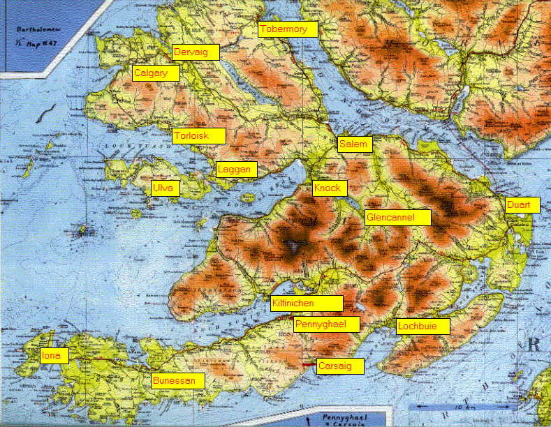
Here's a map of Mull showing Calgary, the area where Inievay and Caillach were.
Here's a map of Mull showing Calgary, the area where Inievay and Caillach were.
A description of Inivea, found on the Mull Historical Society's website, is useful in placing Inivea within the area of Frachadil farm.
“The main area of arable
cultivation appears to have been a broad shelf lying immediately above the
township and extending about 500 m eastwards. Here there are
obvious traces of rig-cultivation, together with what appear to be the
remains of a corn-drying kiln.
“The existence of a farm or
township at ‘Inue’ is recorded on Pont’s
late-16th-century map. At that time it was part of the MacLean
of Duart estates and in about 1670 the lands of ‘Imvie’ paid a rental of £80
Scots. Thereafter, it passed to the Campbells of Argyll, and in 1739 the
2nd Duke of Argyll granted a nineteen-year lease of ‘all and haill the one
pennyland of Inive’ to four sitting tenants at an annual rent of £93 6s 8d
Scots. By the last quarter of the 18th century the township seems to have
been incorporated in the neighbouring farm of Frachadil. It is
not mentioned by name in the census of the Argyll estates made in 1779 or on
Langland’s map of 1801. In 1817 the property came into the hands of
Captain Allan McAskill of Mornish and local tradition says that he evicted the
inhabitants of the township.”
http://www.mull-historical-society.co.uk/daily-life/habitations-ruins/inivea/
Very interesting!!
ReplyDeleteWhere exactly were Lachlan and Mary in the Calgary area, do you know? Inivea?
ReplyDeleteI love the photos at the latter link. Do you know what rig cultivation was?
ReplyDeleteI did look up rig cultivation but there wasn't a clear definition. Here's what I found when I looked again today:
ReplyDelete"Ridge and furrow is an archaeological pattern of ridges (Medieval Latin sliones) and troughs created by a system of ploughing used in Europe during the Middle Ages, typical of the open field system. It is also known as Rig (or rigg) and furrow, mostly in the North East of England.[1][2]
"The earliest examples date to the immediate post-Roman period and the system was used until the 17th century in some areas, as long as the open field system survived. Surviving ridge and furrow topography is found in Great Britain, Ireland and elsewhere in Europe. The surviving ridges are parallel, ranging from 3 to 22 yards (3 to 20 m) apart and up to 24 inches (61 cm) tall – they were much taller when in use. Older examples are often curved.
Ridge and furrow topography was a result of ploughing with non-reversible ploughs on the same strip of land each year. It is visible on land that was ploughed in the Middle Ages, but which has not been ploughed since then. No actively ploughed ridge and furrow survives.
"The ridges or lands became units in landholding, in assessing the work of the ploughman and in reaping in autumn."